By creating digital soil-water management maps, ATK TAKI researchers support planning of natural water retention to offset effects of drought
In recent years, the extreme water supply situations – waterlogging and drought – that have regularly occured in Hungary have altered soil water flow, which in turn has also had an adverse effect on soil fertility. According to the specialists of the ELKH Centre for Agricultural Research’s Institute for Soil Science (ATK TAKI), knowledge of soil properties is of great importance in the fight against extreme events related to the water supply. As a result, these experts are taking on a vital role in deepening and broadening this knowledge within the framework of the National Laboratory of Water Science and Water Safety, which is currently being launched. The project’s tasks include the preparation of digital soil and water management maps for domestic cropland, something which can help predict extreme water management situations and lay the foundations for measures to support natural water retention.
The experiences of recent years have added weight to the forecasts of an increase in extreme temperatures in the Carpathian Basin that exceeds natural variability. In Hungary, a decrease in the annual amount of precipitation, as well as an extreme temporal and territorial distribution, should also be expected. Previous prognoses also pointed out that this will affect the water retention and water-conducting capacity of the soils.
‘Janus-faced’ water
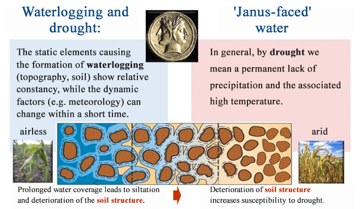
Unpredictable climatic fluctuations, water supply extremes and floods and droughts cause changes in the water circulation of soils (Figure 1), which also affects soil fertility in a sensitive manner. In the current situation of extremely severe drought, the remaining moisture in the soil, which is deeply dried out due to the lack of precipitation and closely adheres to the surface of the soil particles, is only present in a form that cannot be taken up by cultivated plants.

1. Figure: Extremes in water supply: waterlogging and drought. The figure below illustrates the change in the amount of water filling the space between the soil particles. (Source: Labancz V., Makó A., Bakacsi Zs. 2020)
Depending on the soil properties, the same weather situation can have different consequences for soil water management in the case of individual soil types and cultivated plant crops (different sensitivity to drought or waterlogging). The climate-soil-plant relationship system fundamentally determines the framework and future directions of sustainable plant production. The ability to provide water and water supply affect soil biomass production, which is why knowledge of the water circulation properties of soils is expected to become increasingly important in the future. Soil-water management properties depending on the cross-sectional structure and stratification of the soils, the chemical, physical, mineralogical and biological characteristics of the individual layers, the water-conducting and water-holding capacity are decisive in terms of both the water resources available for agricultural production and the soil degradation processes associated with extreme water supply situations.
Factors influencing the water management properties of soils
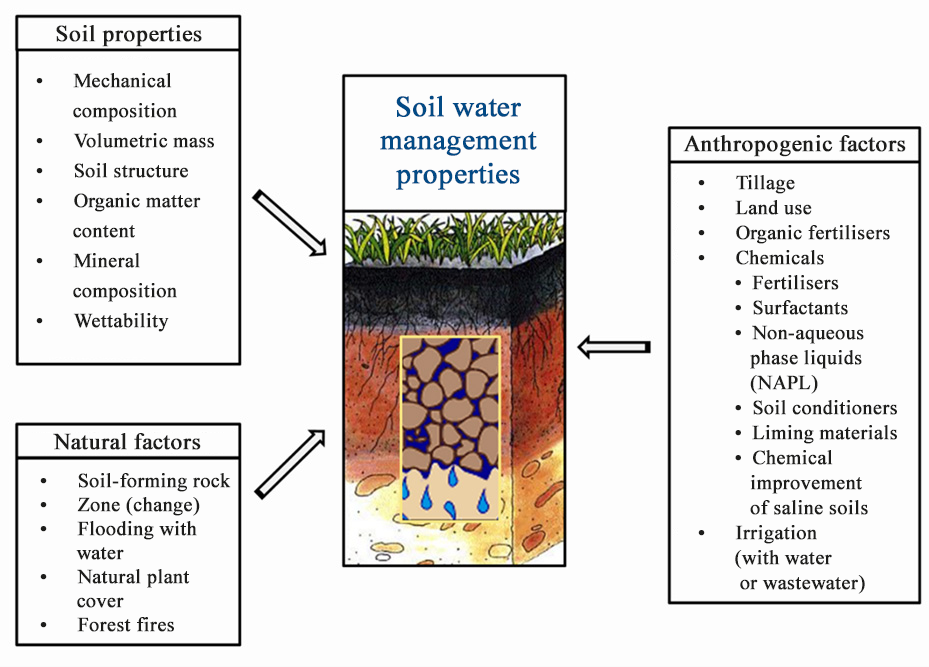
The water retention and movement of water in soils takes place in a pore network enclosed by the solid components of the soil. This means that water management properties are essentially determined by geological and other natural factors that influence the formation and change of the soil pore system, as well as by human impact (Figure 2).

2. Figure: Major natural and anthropogenic factors influencing the water management properties of soils (Source: K. Rajkai., F. Ács., B. Tóth., Makó A. 2018)
One of the most important geological factors determining the pore system and the water management properties of the soil is the soil structure. Almost all the measured soil parameters are in some way related to the structural properties of the soil, which means that they affect water management not only directly but also indirectly through their effect on the formation and stability of aggregates.
Climate change can affect the frequency and extent of soil wetting and drying. Wetting and drying cycles of soils affect not only the weathering that determines soil formation, but also the swelling-shrinking, aggregate formation and compaction processes that are decisive for the formation of structure, thereby also influencing the water management properties. A drying, warming climate increases the rate of formation near the surface, of large-diameter cracks, known as macropores, which drain water quickly. A climate shift favorable to macropores results in water reaching deeper in the cracks, but moving faster does not make the soil more moist, which means there is a reduction in the amount of water retained in the surface soil layers.
Water-repellent (hydrophobic) soil properties may develop due to the decomposition of organic materials on soil surfaces that are significantly warming and drying out as a result of climate change. This can be observed under the mulch layer of pine plantations or on calcareous sandy soils, but it can also occur due to the effect of pollutants or more serious forest fires or stubble burning. The water repellency of soils can amplify the unevenness of water infiltration caused by climate change, as a result of which some areas remain patchily dry, while during intense rain, limited infiltration results in increased surface runoff, water erosion and floods.
The combination of prolonged drought and subsequent sudden, high-intensity rainfall accelerates the degradation of the soil structure. In the case of a sudden increase in moisture, the trapped soil air filling the internal pore spaces of dry soils almost explodes the soil aggregates, thereby increasing the erodibility of the soil surface.
Prevention and mitigation
Some 2% of the agricultural land in Hungary is irrigated, which corresponds to a fifth of the EU average. With comprehensive irrigation development, the share of these areas could be significantly increased. However, due to the cost of the investment and the scarcity of adequate quality irrigation water, this alone is not sufficient. In addition to the quality of the irrigation water, irrigability is also affected by the properties of the given soil, so careful planning and regulation are necessary to avoid the serious soil degradation process and secondary salinization caused by faulty irrigation practices.
Even the soils of areas with particularly good water management are not able to offset the effect of a long-lasting lack of precipitation. In the long term, the solution to the problem is land use that promotes water conservation and water retention, as well as preparation for similar periods of lack of precipitation to become more frequent and lasting.
The use of a properly chosen cultivation method, covering the soil with organic plant residues (mulching) reduces surface evaporation, minimizes the degree of water erosion and the physical degradation caused by cultivation. In this way, it contributes to the maintenance of more favorable soil structure properties and pore conditions, and causes fewer changes to the water management properties of the soil.
Forecasting the soil-specific drought sensitivity of Hungarian growing areas that are changing due to climate change
Knowledge of soil water management is the basis for assessing and protecting water resources potentially stored in the soil. Essential tasks include the renewal of the spatial data infrastructure that contains digital spatial information about domestic soils, the purposefully planned collection of data related to the water management properties of soils – their water-conducting and water-holding capacity – and the development of estimation methods based on easily measurable soil parameters.
Regional water management is aided by water management maps that aggregate soil information in a targeted manner. A more effective solution than ever before to support the prediction of extreme water management situations and the mitigation of the damage caused by them would be the creation of renewable water management maps and hydrophysical databases integrated into state-of-the-art GIS systems, which contain reliable information about the deeper layers in addition to the surface soil layer.
The map materials and associated textual explanations kept in the databases of the former large-scale agricultural plants, land offices, county plant protection and agrochemical stations provide basic and additional soil information about the state of domestic cropland. Maps for the purpose of soil physics and water management, which can be created by geospatial processing of the data extracted from these, can provide basic information for, among other things, the development of the Operational Drought and Water Shortage Management System, the foundation of irrigation development investments, and the further development of the current waterlogging hazard map methodology. A more detailed knowledge of the water management properties of soils, together with maps summarizing national spatial data, could also help the development of measures to support natural water retention, the modeling of underground water resources, the development of an agricultural water management policy program, and the prediction of expected soil movements due to weather extremes.
The Hungarian National Laboratory of Water Science and Water Safety, which will be launched this year, will be established to conduct water science and water safety research that contributes to the protection of domestic water quality. The ELKH Centre for Agricultural Research’s Institute for Soil Science will participate as a consortium member in the implementation of the project. As part of the project, it will seek answers to the problems outlined above, including by creating digital soil and water management maps for domestic agricultural areas to support the prediction of extreme water balance situations, with detailed investigations of the structural properties of the soil, including by establishing measures to support natural water retention.

